Why is it in the news?
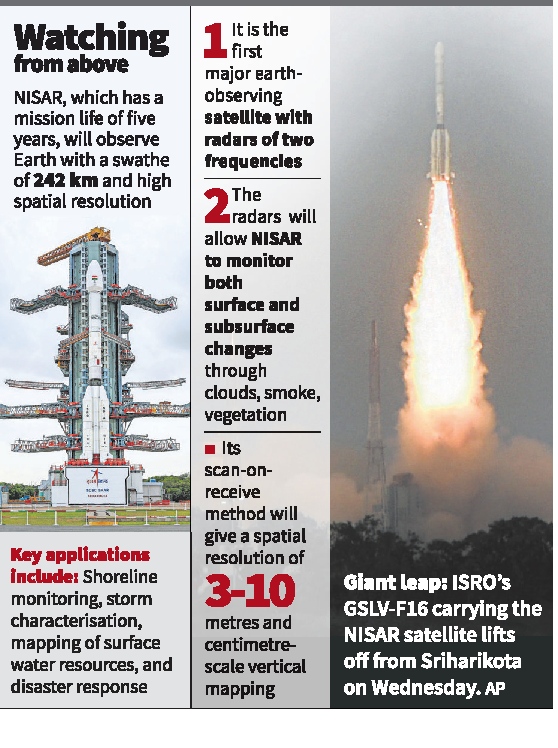
India has successfully launched the NISAR (NASA-ISRO Synthetic Aperture Radar) satellite from the Satish Dhawan Space Centre in Sriharikota. This marks a significant achievement in international collaboration in the field of space research.
Launch Details
-
The launch was conducted using the GSLV-F16 rocket on Wednesday at 5:40 PM.
-
The rocket placed the satellite in a sun-synchronous orbit within 18 minutes.
-
The satellite weighs 2,392 kilograms.
First Joint Satellite by NASA and ISRO
-
NISAR is the first satellite to be jointly developed by the Indian Space Research Organisation (ISRO) and the National Aeronautics and Space Administration (NASA).
-
It has a planned mission life of five years.
-
NASA provided the L-band radar system and other key components, while ISRO developed the S-band radar, the spacecraft bus, and handled the launch.
What Makes NISAR Special
-
NISAR is the first satellite in the world to use dual-frequency Synthetic Aperture Radar (SAR), combining NASA’s L-band and ISRO’s S-band radars.
-
It is equipped with a 12-metre wide mesh reflector antenna, which will be deployed nine metres away from the satellite body.
Objectives of NISAR
NISAR will scan the Earth day and night, in all weather conditions, with data available every 12 days. It will help in:
-
Monitoring natural disasters like earthquakes, floods, and landslides
-
Tracking ground deformation and ice sheet movement
-
Observing vegetation and forest changes
-
Mapping agricultural lands and improving crop planning
-
Studying soil moisture and surface water resources
-
Monitoring sea ice, ships, shorelines, and storm patterns
Mission Phases
-
Launch Phase – Successfully completed with the GSLV-F16 launch
-
Deployment Phase – The 12-metre antenna will be deployed 10 days after launch
-
Commissioning Phase – System testing and calibration
-
Science Phase – Begins after commissioning and continues for five years
Relevance for UPSC Aspirants
-
Demonstrates India–US collaboration in science and technology
-
Relevant for GS Paper III (Science & Technology, Environment, Disaster Management)
-
Can be asked in Prelims under current affairs or in Mains as an example of technological advancement
Study Tip
Understand key terms such as Synthetic Aperture Radar (SAR), sun-synchronous orbit, and review other Indian Earth observation satellites like RISAT, Cartosat, and Oceansat for better context.